Laredo - Proposed Road Closure & Land Use Changes
What is being proposed?
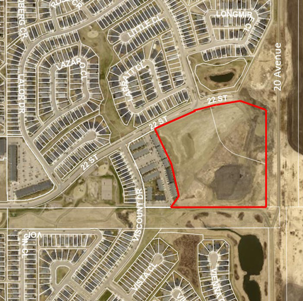
The City has received an application concerning a ±8.26 hectare (±20.41 acre) area in the Laredo neighbourhood that proposes to close a portion of road, amend two statutory plans, and rezone the area to allow for a mix of residential and open space uses.
Proposed Lancaster - Vanier East NASP (pdf)
Location
Specifically, the application is to:
- Close a ±2.23 hectare (±5.51 acre) portion of road south of 22 Street along the west side of 20 Avenue,
- Amend the East Hill Major Area Structure Plan (MASP) to no longer identify district commercial uses in the ±6.03 hectare (±14.90 acre) area next to the proposed road closure area.
- Amend the Lancaster / Vanier East Neighbourhood Area Structure Plan (NASP) to no longer identify road and commercial uses in this area and to add other residential uses in their place,
- Amend the Land Use Bylaw (LUB) to rezone the area from “Road” and “County Agricultural District AG” district to:
- R1A – Residential (Semi-Detached Dwelling) District
- R1G – Residential (Small Lot) District
- R2T – Residential (Town House) District
- R2 – Residential (Medium Density) District
- P1 – Parks and Recreation District
A specific development proposal is not part of this application. What is being considered is only the proposed road closure and the identification and rezoning of the area for residential and open space uses. If approved, the developer would then need to apply for subdivision approval and development permits prior to construction. Details such as building height, setbacks, on-site parking, and landscaping are determined at the development permit stage and are not part of this application.
What are the next steps for this proposal?
It is anticipated that the proposed amendments will be presented to Council for consideration in the fall of 2023.
- Step 1: Council reviews administration’s report and recommendation when considering First Reading. If First Reading is granted, the application moves onto Step 2.
- Step 2: A Public Hearing is held where the public is given an opportunity to speak directly to Council about the proposed amendments. Public Hearings are advertised in the Friday edition of the Red Deer Advocate and all landowners within the 100 metre consultation area will receive written notification of the Public Hearing. Once the Public Hearing is closed, the application moves onto step 3.
- Step 3: Following the Public Hearing, Council considers Second and Third (final) Reading of the proposed amendments.
Questions?
Questions regarding the application can be forwarded to Orlando Toews, Senior Planner at: orlando.toews@reddeer.ca or ph. 403-406-8704.
Do you have any comments?
If you wish to provide comments, please submit them by 4:30 p.m. on September 20, 2023. All comments provided will form part of the public record and will appear on a Council Agenda in the same format they are received. In accordance with The City’s Procedure Bylaw, anonymous comments will not be forwarded to Council and personal information will not be removed. Please note that administration may not be able to respond to all questions and inquires about this proposal.
Comments can be submitted by one of the following methods.
- Email: planning@reddeer.ca
- Mail to: Attn Orlando Toews, City Planning & Growth, Box 5008, Red Deer, AB T4N 3T4
- Drop off written comments at City Hall: Attn Orlando Toews, City Planning & Growth, 4914-48 Ave, Red Deer, AB
Summary of Proposed Amendments
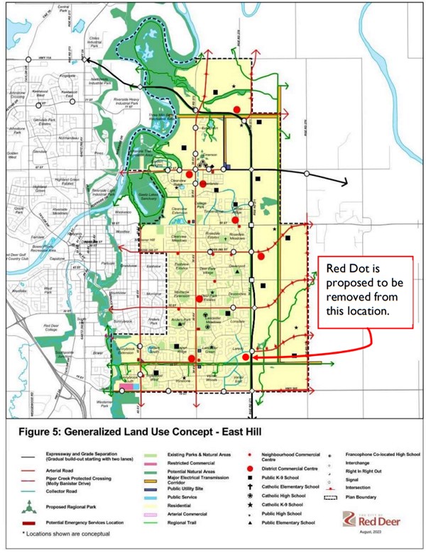
Proposed Amendment to the East Hill Major Area Structure Plan (MASP)
(Bylaw 3499/A-2023)
The proposed amendment removes the red dot that had identified this area as a potential “District Commercial Centre”.
A copy of the current East Hill Major Area Structure Plan can be found here.
Proposed Amendments to the Lancaster / Vanier East Neighbourhood Area Structure Plan (NASP)
(Bylaw 3217/B-2023)
NASPs are conceptual plans that illustrate how a neighbourhood is anticipated to develop; they show such things as road locations and types of land uses, e.g., residential, commercial, parks, etc. The following two sketches show a portion of the current NASP’s land use concept, Figure 5, and the proposed changes to that same area. There are also numerous text updates proposed for the NASP that would reflect these land use concept changes.
A copy of the current Lancaster / Vanier East Neighborhood Area Structure Plan can be found here.
A copy of the proposed Lancaster / Vanier East Neighborhood Area Structure Plan can be found here: Proposed Lancaster - Vanier East NASP (pdf)
Excerpt from Figure 5 – Generalized land Use Concept – East Hill
CURRENT Figure 5 Land Use Concept
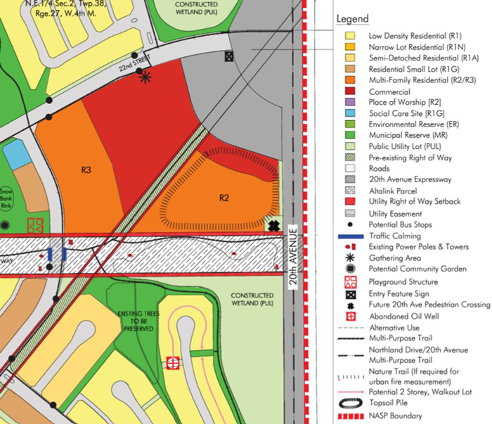
PROPOSED Figure 5 Land Use Concept
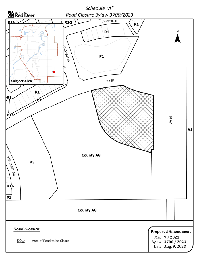
Proposed Road Closure Area
(Bylaw 3700/2023)
This sketch illustrates the area of road that is proposed to be closed. This land was originally acquired by the City in anticipation of the future construction of a grade-separated intersection as part of the 20 Avenue expressway. That is no longer the case; the 22 Street / 20 Avenue intersection will have a roundabout, which requires less land. Therefore, the surplus land is proposed to be sold to a developer and used for residential uses in conjunction with the developer’s large parcel adjacent to it.
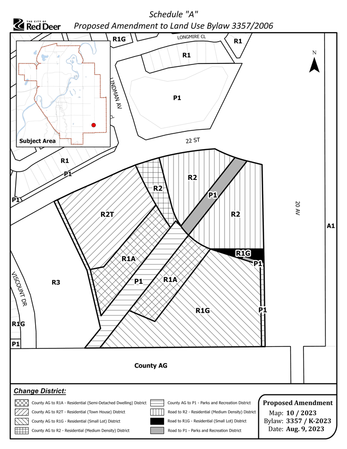
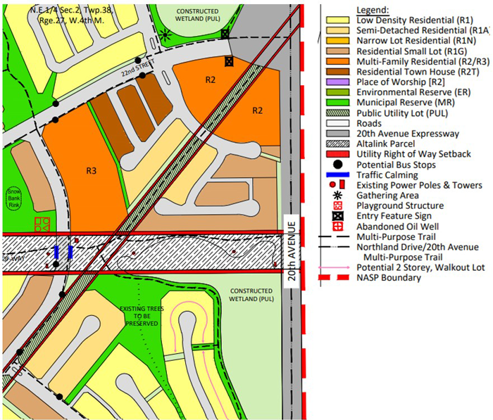
Proposed Amendment to the Land Use Bylaw (Rezoning)
(Bylaw 3357/K-2023)
This sketch illustrates the land use districts (zonings) that are proposed to be applied to the subject area.
The City of Red Deer Land Use Bylaw districts can be viewed here.